The Dynamical Feedback Cascade of Earth illustrated by the Barotropic Governor Mechanism, and the AMOC
Or how the climate system escalates...

In recent years, especially since the temperature jump in 2023 extreme events are increasing in frequency, intensity, and area extent. Abrupt regime shifts of hydroclimatic conditions are observed in a rising number of regions. Sudden non-linear signals of all sorts of extreme events emerged. Be it heat and drought compound events, extensive large scale flooding events, regions where rapid intensification’s of storms became the norm, while concurrently weather whiplash events which are characterized by fast swings between extremely hot and dry into very wet and stormy conditions and back again that follow non-linear trajectories spreading fast wrapping it all up.
It had been the most intense events far outside our historical experience that taught us the same story, over and over again: All these recent emerging truly exceptional events had been the consequence of feedback chains that operated over long distances interacting non-linear with regional drivers. Currently, the understanding is emerging that it’s not global warming per se that drives the recent intensification of extreme events. It just provides the elevated baseline from where upstream extremes can drive the intensification of downstream events. In a way intensifying extreme events alow downstream events to become even more intense. At first a warmer mean state intensifies extreme. If thresholds are breached extremes intensify via a feedback chain driven by signal amplification.
With time patterns started to emerge with distinct regions becoming prone to specific kinds of extremes driving regional trends. A rising number of studies indicates that we are in the process to witness how a new planetary wave guide establishes in both Hemispheres driven by e.g. emerging sea surface temperature patterns, sea ice losses, Arctic amplification, or persisting soil moisture anomalies. We observe how distinct regions become more prone to heat and drought while others are flooded regularly.
One such region is northern India which combines both extremes, residing side by side. A region home to hundreds of millions of us. After 1999 the monsoon pattern over Northern India underwent a regime shift. Rainfall extremes started to concentrate in Northwestern India, while the Indo-Gangetic Plain started to dry out and became a hot spot for compound heatwave drought events.
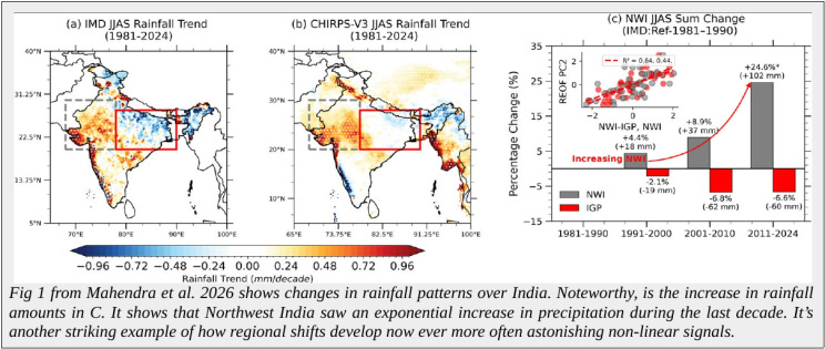
This shift resulted in the emergence of extreme events far outside of the historical range. Be it large scale and massive flooding events in Northwestern India that can last for more than a week and happen regularly now, or over the Indo-Gangetic Plain which became a hot spot for heat-drought compound events becoming ever more extreme now nearing the thermal limits we can endure. The drivers, mechanisms, and principals behind the chain of events supporting the formation of the extreme weather dipole over Northern India are a good example of how the emerging dynamical feedback reaction of Earth’s climate system operates in a system dominated by the behavior of fluids.
The chain of amplification processes started in the North Atlantic
A common principle behind the recent non-linear intensification of extreme events is how distant regime shifts intensify regional extremes via teleconnection chains that can pass on a strengthening signal driven by regional amplification processes between the surface and the atmosphere. This signal amplification is one driver of the recent massive intensification of local extreme events which start now to be far outside our historical experience.
For Northern India the drivers behind intensifying flooding and heat extremes originated in the North Atlantic. Since the 2000s a shift and intensification of sea surface temperature patterns had been observed. It’s a common occurrence that ocean regions develop nowadays a leading influence on circulation patterns. Not only that shifts in sea surface temperature patterns are often more persistent than over land some key regions develop now a permanent influence on atmospheric circulation patterns.
In terms of the North Atlantic its the intensification of the Gulf Stream frontal system. The warming of the Gulf Stream accelerated from ~0.2°C per decade post 1999 to ~0.8°C after it. Stronger temperature differences between the current and neighboring water masses started to interact stronger with the overlying atmosphere. Noteworthy, something similar happens with all frontal systems of the western boundary currents that transport heat poleward at the eastern flanks of the continents (video showing the location of the western boundary currents). These intensifying ocean fronts developed the last two decades a persistent impact on the global circulation patterns in both Hemispheres.
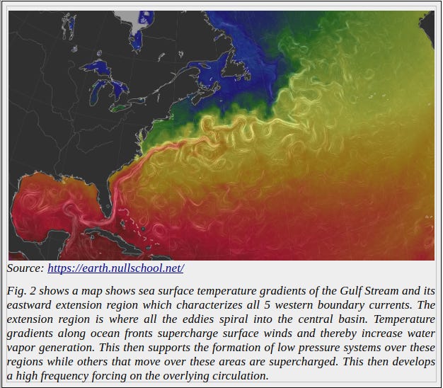
The intensifying temperature front along the Gulf Stream acts like a birth place for low pressure systems as water vapor generation is enhanced by stronger surface winds across sea surface temperature gradients. The signal from the low pressure systems forming over the Gulf stream front is then intensified by the cold blob in the subpolar Atlantic. A persisting area of cooler than normal sea surface temperatures.
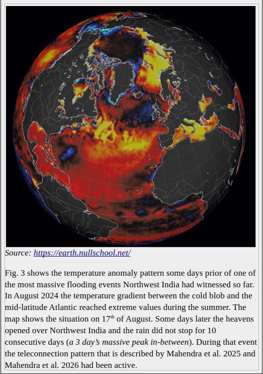
The cold blob during winter is discussed as a result of a weakening AMOC circulation. This cold blob persists into the summer. In the warm season sea ice melt and atmospheric circulation patterns contribute to it’s persistence. Then to the south we have ocean regions that warm fast. Marine heatwaves during summer can greatly intensify the meridional temperature gradient in this area where warm and cold anomalies collide as it can be seen in the map below.
Fig. 3 and 4 show how extreme north/south temperature gradients speed up the jets. The jet streams are fast upper level air currents that tend to follow temperature gradients - the thermal wind balance. Meridional gradients speed the jet up in the eastward (zonal) direction. To the contrary zonal temperature gradients redirect the jet into the meridional direction – it becomes wavier.
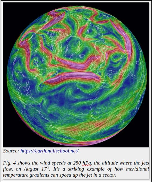
If upper level winds intensify they supercharge weather events on the surface if conditions are favorable. For example they drag lower level air upwards supporting convection and transport accelerated momentum into other regions where a subsequent chain of high pressure systems and low pressure systems are intensified while weather systems are dragged along.
The SST pattern in the North Atlantic started to emerge after the 1999 (fig. 5). Since then it developed a leading influence on zonal flow patterns over Eurasia which lead to a fundamental reorganization of the monsoon system over Northern India.
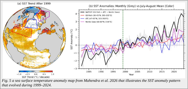
The North Atlantic is one of several ocean regions which developed a leading influence on global circulation patterns the last two decades. Other areas would be the North Pacific summer marine heatwave which intensified massively since 2019, or the Southern Hemisphere mid-latitude warming band where western boundary currents transport more heat into their extension regions.
Atmosphere surface interactions can act as signal amplifiers passing on disturbances over thousands of kilometers
We live in a world of fluids which are governed by gradients. In the atmosphere horizontal momentum interacts with vertical momentum fueled by water vapor levels and gradients in temperature, density, geopotential height differences (height of the atmosphere), and intensifying surface-atmosphere interactions.
The graph below shows one kind of mutual amplification in a kind of dipole structure between a low and a high.
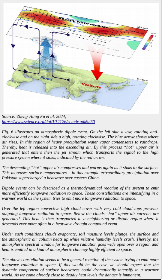
In a warmer world such kinds of interactions can fast and suddenly develop a non-linear oscillatory behavior – be it local, regional, over parts of a Hemisphere or if you warm the planet too fast too long all the way up to the planetary scale.
In principle our atmosphere functions like a system of cogwheels connected by strings that move through them. Highs and lows are rotating air masses of opposite direction in which air rises or sinks that interact with upper level air currents that flows between these pressure centers.
High pressure systems in the Northern Hemisphere rotate clockwise (blue arrow where air rises) while low pressure systems rotate counter-clockwise (red arrow where air sinks). This makes it possible that both rotations can mutually reinforce each other – it’s easier to rotate if a neighboring system rotates in the same direction where both vorticies come close to each other.
Thereby they pull in their middle large amounts of air to the north or south depending on the side (here a video showing how large these air mass movements have become in a warmer climate). The resulting air mass movements can trigger the next chain of events where signals are passed on.
For example regions with a warmer higher air column besides regions with a lower, cooler air column can modulate the location of upper level winds like the jets. The jets follow the pressure level of the upper troposphere. The expanding air moves this pressure level upward thereby warm temperatures act like ridges for the jets while colder ones act like troughs – higher temperatures expand the air column while colder ones contract the air column with the jet being guided by their changing “topography”.
If temperature differences between highs and lows intensify the curvature of the upper troposphere gets “wobblier”. This alters the course of the jets which interact with vertical air movements. Important here that vertical and horizontal air mass movements can mutual amplify under certain conditions resulting in nonlinear amplification processes.
One of our problems in a warmer world will be the tendency of surface temperature gradients, low pressure systems, high pressure systems, and jet streams to undergo mutual amplification processes in an area for some time. These kind of “disturbances” will grow in area extent and impact with further warming. Eventually they will reach the planetary level as the example of a collapse of the Atlantic Meridional Oscillation (AMOC) will show later.
Figure 7 shows such a chain reaction in this case originating from the North Atlantic reaching all the way to Northern India. The whole section is part of a circumglobal teleconnection (CGT) pattern over the Northern Hemisphere which intensifies in a warmer climate – segments of it will peak ever more often e.g. driven by sea surface temperature peaks caused by marine heatwaves in addition to continental drying or flooding events as well as high latitude forcing (e.g. summer sea ice loss) and intensifying tropical convective centers over suddenly warming ocean surfaces and the movements of tropical depressions. For example the tracks of intensifying tropical depressions of the Madden-Julian Oscillation which move from the Indian Ocean near the equator into the Pacific Ocean effect global circulation patterns all the way to the polar regions.
Regional extremes can reach now to such an extent an extreme state that they can trigger circumpolar teleconnections that are passed on by circulation patterns and their corresponding extremes. The disturbances also reverberate into higher and lower latitudes. Thereby, extreme events can reach such magnitudes that circulation patterns over the whole planet are impacted.
One example would be the recent jumpwise increase in the number of sudden stratospheric warming events in both polar regions, especially in the Arctic. When the air in the stratosphere spills out to the surface of the Arctic the spillover effect of equatorward moving cold air can fast become global in reach.
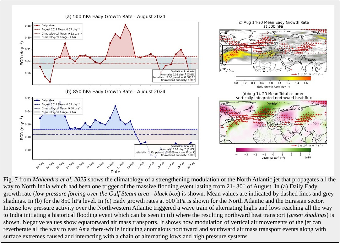
In our case we have an intensifying Gulf Stream front supercharging low pressure systems which then are reinforced by faster “straighter” jets in this region. A straight forward reaction of meridional temperature gradients that intensified between cold and warm SST patterns across the North Atlantic. It’s these often rapid intensification’s of seasonal, weekly or daily gradients that become the main amplifier of extreme events in a warmer world which reach magnitudes that allow far reaching effects. These ripple on in the form of a chain of extreme events down the road where forms of regional signal amplification comes into play.
The Barotropic Governor Mechanism
The Barotropic Governor Mechanism is a striking example where theoretical atmosphere physics proposed a mechanism that became decades later one of the leading feedback mechanisms that intensifies now extremes world wide. This mechanism describes how two highs sandwiching a low pressure system amplify a signal of eastward progressing kinetic energy of a supercharged jet via energy conversions between upper levels flows and rotating air masses below. The Barotropic Governor Mechanism becomes operational in a warmer world with strengthening teleconnections of anomalous mass and energy transports over long distances. It acts like a kind of regional signal amplifier. At it’s core surface-atmosphere coupled extremes that reinforce signals in the form of incoming mass and energy into a sector.
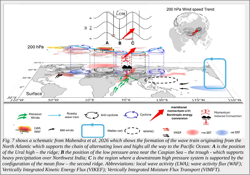
A, B and C are the regions where the Barotropic Governor Mechanism operates. The players are a fast jet hitting into region A where we have the Ural high which supports the formation of a low in region B east of the Caspian Sea, which feeds back again into the high in region C. The fast jet supercharged over the North Atlantic arrives in region A the Ural high. Over the high a exit region forms in the jet where air leaves it to sink down in the high pressure system.
The sinking motion in A then spreads equatorward at the surface supporting the formation of a cyclone near the Caspian Sea. In this region, between A and B the jet looses its energy (or mass) while the cyclone in B is receiving part of the mass at it’s base from the high. On the eastern side of the cyclone in B heavy precipitation sets in over Northwestern India if moisture levels are high enough which is generally the case during the monsoon season.
The rising air is moving northeastward in the upper troposphere injecting kinetic energy in the Asian jet core entry region where air enters it. It’s entrance region broadens and the jet speeds up between B and C towards the high pressure system. This acceleration of the jet then reinforces heavy rainfall over India as the speeding up jet in this sector creates a mass deficit at its entrance region which starts to pull in air thereby amplifying vertical upward air movements below it.
The enhancement of upper level flow intensifying convective activity below can breach thresholds and the moisture inflow from the Arabian Sea starts to reach such magnitudes that the constellation can become self preserving.
The interactions and amplifications between the high in A, the low in B, and the high in C with the weakening and then again strengthening upper levels winds in-between is called the “Barotropic Governor Mechanism”. It’s describes the non-linear interaction of a high which supports the formation of an eastward located low which both convert zonal kinetic energy from the mid-latitude jet into meridional eddy kinetic energy. This then feeds back on the eastern side of the low via intensifying precipitation into the upper level Asian subtropical jet which starts to accelerate in this area. Thereby, northeastward progressing kinetic energy in the upper troposphere is transformed back again into zonal kinetic energy of the mean flow both mutually intensifying.
The “Barotrophic Governor Mechanism” is kind of a signal amplifier which can be further intensified by local extremes at the surface like dried out soils intensifying heat in the high pressure regions of A and C or intensifying moisture transports from fast warming upper oceans enabling a new class of flooding events in the convective region B which feeds energy into the hot region downstream to C in the east.
With each new temperature jump the chances will rise fast that such teleconnection patterns and the intensification via regional non-linear feedback processes will see further jumpwise increases. As we just had another temperature jump from 2022 to 2024 by ~0.4°C (mean warming by ~0.3°C) with India’s heatwaves seemingly reaching again new record values in 2026 we can expect another jumpwise intensification of flooding and heat over Southeast Asia mutually supporting each other with the coming temperature jump that builds currently up inside the system. As we already are close or above deadly temperature thresholds in some events a regular occurrence of heat suddenly breaching absolute deadly thresholds by a good margin is close now.
The collapse of the AMOC used as an example of how the warming driven feedback cascade of Earth operates
It seems that we have missed the main feedback cascade in the Earth system. It’s not iconic systems like ice shields, thawing permafrost soils, regime shifts in boreal forests and rainforests, burning peat soils in Southeast Asia or a collapse of the AMOC. They kick in at a later stage of the feedback cascade we have already triggered.
The feedback cascade we unleashed operates at a much more fundamental level and that from pole to pole. It’s not a feedback cascade where once stable systems start to shift fast. It’s a feedback cascade that starts with the more dynamical parts of the Earth system that go into mutual amplification mode that forces eventually slowly changing systems into abrupt regime shifts.
The cascading reaction of the dynamical parts progresses via intensifying variability in pressure, density, speed, saltiness, temperature, air and soil moisture levels and their gradients. Sudden increases in water vapor levels during temperature jumps and intensifying water vapor transport in the atmosphere, often in the form of strengthening atmospheric rivers. Strengthening oscillations of and between ocean-atmosphere circulation patterns (e.g. climate modes), non-linear marine heatwave expansion and intensification, and sea ice looses that lead to sudden reductions in cloud cover over large regions at the same time. Other components that start now to show a higher variability or accelerated trends are currents and eddies that intensify or weaken in the oceans and atmosphere.
The feedback cascade of the dynamical parts of the system also involves massive droughts and heatwaves that mutual interact with massive flooding events which act like kind of wave guides for the jets. The feedback cascade also functions via suppressed mixing processes over the upper oceans as they stratify fast and density differences intensify over the upper water column. Which then supports fast spreading and intensifying marine heatwaves in the oceans driven by ocean-atmosphere circulation feedback’s that involve various thresholds from which non-linearity sets in. Another expression are sudden stratospheric warming events now happening regularly over both poles. During these events cold air swaps out of the polar regions while in another area warmer and moister air is pulled into the Arctic air cell whose circulatory effects are global in reach.
The feedback cascade is in principle a chain reaction between the dynamical parts of the system that works it’s way upward with extremes or series of extreme events that reach such magnitudes that the iconic tipping elements of Earth suddenly tip faster than predicted. With time principles started to emerge how the feedback cascade gains in strength.
It starts with the a regional peaking variability and accelerating trends of gradients in all four domains of the climate system – oceans, land, ice, atmosphere. In our case it had been an intensifying sea surface temperature gradient over the North Atlantic. All these signals of weakening and strengthening gradients then allow a stronger coupling between systems. This is where mutual amplification gains in efficiency as the systems “organize” to a higher degree in a warmer climate allowing the systems to couple stronger, be it in one or bidirectional
Mutual amplification then allows stronger peaks in the subsystems. As a consequence stronger teleconnections of anomalous mass and energy transports gain in reach and strength. With time the impacts on the single subsystems intensify non-linear via extreme event intensification which collide with systems that lost their resilience and became prone to sudden shifts.
This can be thinner sea ice, an Amazon already drying out over large areas making it prone to a sudden increase in extremely large wildfire complexes as they spread fast, high levels of summer stratification and subsurface heat in an ocean area preconditioning the area for a extensive summer marine heatwave that will allow super storms to form during a season or an Arctic landscape dried out during summer because of a historical heatwave while accompanying summer sea ice loss and moisture transports into the Arctic in other sectors lead to a sharp increase in lightning storms setting the tundras ablaze.
It’s an amplification chain between intensifying upstream events that force downstream events to become even more extreme. In the last stage non-linear behavior spreads fast inside the system finally reaching important climate modes and iconic systems that operate at the planetary level.
All these sudden shifts and extreme events in all these systems and regions can then lead to a series of exceptional extreme events impacting the Arctic causing sudden sea ice losses and massive melt events over the Greenland ice shield which then opens up the possibility of a sudden shut down of the AMOC which is part of the non-linear stage. Thereby, a collapse of the AMOC becomes another signal amplifier of the already ongoing feedback cascade with global consequences.
While large parts of the Arctic would cool, parts of the subtropics would heat up faster. The areas and seasons where meridional temperature gradients intensify fast would be the times when the zonal circulation would be supercharged to levels far beyond our experience thus transmitting a sudden intensification of circulation patterns in downstream areas over large distances. And it will be the daily, weekly massively intensifying gradients that will have the largest impact, which can then trigger e.g. the collapse of the Amazon during a truly exceptional event.
In the years after the collapse of the AMOC extremes world wide would be forced to undergo another round of intensification with us loosing our predictive skills to forecast which area or region will be hit next. The moment the feedback cascade reaches the iconic tipping elements they would act as signal amplifiers transmitting stronger signals of abnormal movements of mass and energy inside the system that ricochet back and forth inside our world regulated by fluids. These chain reactions would ripple all the way to the polar regions of both Hemispheres whose extremes feed back into the other Hemisphere as both are interconnected. We set loose a kind of ping pong reaction between regions and their systems that undergo extreme state shifts or intensification’s with circulation patterns being the main driver – be it in the oceans or atmosphere.
We already observe all of the above to happen as it’s especially the extremes that intensify non-linear now. A sudden AMOC collapse would just introduce abruptly a new dynamic into an already non-linear changing system. “Weather”, or short term fluctuations would take the lead. The moment weather becomes climate when single events reach such intensities that they develop a long lasting impact on the warming rate we are in deep trouble.
This is where we are now. For our civilization the main problem of global warming seems to be the rapid intensification of extremes which has all the potential of a water world heating up fast to further scale up. It’s the super storms James Hansen warned us about, but it’s also super heatwaves, super flood disasters, super melt events, super marine heatwaves, super tornado seasons, super storm seasons, super wildfire outbreaks massive in scale and intensity that will be our downfall.
It seems that our main error had been to assume that Earth is a sluggish system, as it seems to be the opposite. We knew that Earth is a non-linear system. Now we realize that it can change fast driven by it’s dynamic components...
Sources:
“Missing Summer Westerly Jet Barotropic Governor Effect Explains Climate Models—Observation Discrepancies in the Indian Monsoon Trends”; Nimmakanti Mahendra, Nagaraju Chilukoti, Xiaoqing Liu, Jasti S. Chowdary, Lei Wang, Matthew Huber; AGU Advances, vol. 7, 2026; DOI: 10.1029/2025AV002173; online: https://agupubs.onlinelibrary.wiley.com/doi/full/10.1029/2025AV002173
“Stagnation of Atmospheric Circulation Leads to Historically Prolonged Extreme Rainfall Event Over Northwestern India in August 2024”; Nimmakanti Mahendra, Matthew Huber, Lei Wang, Kieran M. R. Hunt, Nagaraju Chilukoti, Jasti S. Chowdary; AGU Atmospheres, vol. 130, 2025; DOI: 10.1029/2025JD044227; online: https://agupubs.onlinelibrary.wiley.com/doi/10.1029/2025JD044227?af=R
Extremely scary stuff indeed. It seems that we are already locked-in to huge changes to our globally-driven weather with no way out.
What happens when we mess with the main creators of cloud-based land and ocean temperature moderation, nutrients in the broader ocean and deforestation on land. Spreader levee and appropriate nutrient rebalance of the ocean should be our primary goals. There was a good article which looks at oxidation rates of iron in the ocean when we lose the fish/microbial interplay to keep iron in a bioavailable form. https://phys.org/news/2026-04-diversity-iron-marine-life.html